Two views of a small ...
waterfall in lower
Dutch Flat Canyon
or
Dutch Flat Canon
or
Dutch Flat Ravine
beneath the washed-out Bear River Road bridge.
I cannot determine yet (via Google) the name of the creek - or even that is has a name.
My map of the route I drove (mostly) can be seen here.
With flash:
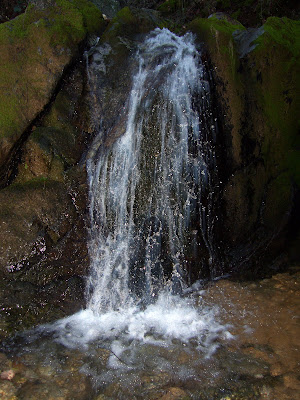
Without flash:

Related text:
Statistics Of Placer County - 1861
Report of J. Ross Browne on the Mineral Resources of the States and Territories West of the Rocky Mountains - 1867
Resources of the Pacific Slope - 1869
Report of the Chief of Engineers U.S. Army - 1891
The Country God Made
By Arthur Colton
Pulished in "The Reader - an Illustrated Monthly Magazine" July 1906"
Engineering and Contracting - A Weekly Journal for Civil Engineers and Contractors - Volume 29
Published by The Myron C. Clark Publishing Co., 1908
Related pictures:
Dutch Flat Little York road bridge
Halsey & Coffin (Studio in Dutch Flat operated by Henry H. Halsey and Isaac Tibbetts Coffin, landscape photographers, 1874)
Handwritten description in period pen on the verso says, "Dutch Flat Canon, tail flumes and undercurrents Little York road bridge."

Source = http://www.westernminingstocks.com/dutch-flat-little-york-road-bridge-halsey-amp-coffin.html
Scene in the Ravine below Dutch Flat


Sources http://www.californiapioneers.org/lh/index.php and http://content.cdlib.org/ark:/13030/kt5v19q14m and
Map of the Dutch Flat, Gold Run, Little York & You Bet mining districts

Source http://content.cdlib.org/ark:/13030/hb0199n6m7
Dutch Flat Canyon
or
Dutch Flat Canon
or
Dutch Flat Ravine
beneath the washed-out Bear River Road bridge.
I cannot determine yet (via Google) the name of the creek - or even that is has a name.
My map of the route I drove (mostly) can be seen here.
With flash:

Without flash:

Related text:
Statistics Of Placer County - 1861
Why Not Ditch takes water from Dutch Flat Ravine to Why Not Claims. Length, 1 mile; capacity, 150 inches; value, $1,100.
Report of J. Ross Browne on the Mineral Resources of the States and Territories West of the Rocky Mountains - 1867
The Yankee, at the junction of Dutch Flat ravine with Bear river, has worked off nearly all the soft gravel. In 1858 and 1859 it was worked as a drift claim by 16 men, and it yielded 250 ounces (about $4,500) per month.
Resources of the Pacific Slope - 1869
Between Dutch Flat Ravine and Squire's Canon are a number of hydraulic claims that have been worked many years, and have paid very little more than expenses.
Report of the Chief of Engineers U.S. Army - 1891
DUMPS OF DUTCH FLAT AND LITTLE YORK.
The Dutch Flat mines dump directly into the Bear down the sides of the canon, through Dutch Flat Ravine ... In places the material piled up to a height of many feet, notably at the mouth of the Dutch Flat Саnоп, where it once formed a dump 35 feet high, and extending across to the opposite bank, and up and down stream for 200 yards each way; but they are either entirely cut away, or, where the alignment of the caîion side protects it, only narrow rims or banks are left. Dutch Flat Canon, where large quantities were lodged at one time, as shown by rims from 10 to 30 feet high, is now being mined out, and at its mouth is a low fresh pile from this source, flanked on each side by remnants of the former dump 15 to 20 feet above it.
The Country God Made
By Arthur Colton
Pulished in "The Reader - an Illustrated Monthly Magazine" July 1906"
Half a spring morning, then, we traveled together over the next ridge by the hamlet of Little York, down into Bear Canon, where the bridge had been swept away by floods and one crossed the river by an uncertain plank, and up again, hill piled on hill, steep road and heavy footing in the red mud, toward Dutch Flat.
Engineering and Contracting - A Weekly Journal for Civil Engineers and Contractors - Volume 29
Published by The Myron C. Clark Publishing Co., 1908
Nevada City, Cal. --- Supervisors of Nevada and Placer Counties have agreed on plans for bridge to be erected over Bear River near Dutch Flat. Bridge will be about 300 ft. long and will cost $6,000.
Related pictures:
Dutch Flat Little York road bridge
Halsey & Coffin (Studio in Dutch Flat operated by Henry H. Halsey and Isaac Tibbetts Coffin, landscape photographers, 1874)
Handwritten description in period pen on the verso says, "Dutch Flat Canon, tail flumes and undercurrents Little York road bridge."

Source = http://www.westernminingstocks.com/dutch-flat-little-york-road-bridge-halsey-amp-coffin.html
Scene in the Ravine below Dutch Flat


Sources http://www.californiapioneers.org/lh/index.php and http://content.cdlib.org/ark:/13030/kt5v19q14m and
Map of the Dutch Flat, Gold Run, Little York & You Bet mining districts

Source http://content.cdlib.org/ark:/13030/hb0199n6m7

Comments